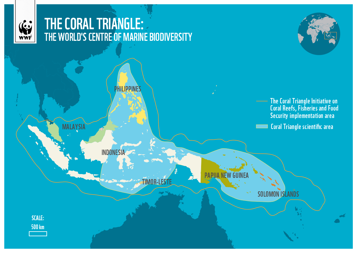
The Coral Triangle Area consistently draws the attention of marine scientists worldwide. Why does this 75,000-square-kilometer coral reef region, encompassing the waters of six countries—Indonesia, Malaysia, the Philippines, Papua New Guinea, Timor Leste, and the Solomon Islands—host such extraordinary marine biodiversity? This region is home to 520 coral species, around 3,000 species of fish, and 150 million coastal residents who depend on marine resources, with an economic potential estimated at USD 2.5 billion annually. No other marine region in the world matches its biodiversity richness.
While the Amazon rainforest in Brazil boasts the world’s highest terrestrial biodiversity—with 16,000 plant species, 1,300 bird species, and 430 mammal species—the Coral Triangle Area, often called the “Amazon of the Sea,” holds the title for marine biodiversity.
The Coral Triangle Area
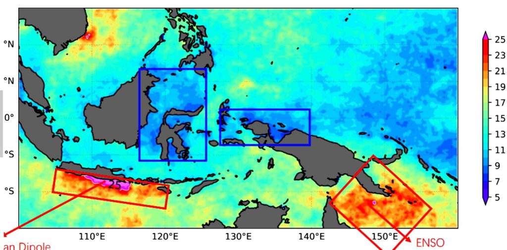
Global scientists continue to investigate the reasons behind the Coral Triangle’s incredible richness. Indonesian and Chinese marine experts have linked the presence of coral reefs in Indonesian waters to the phenomenon of marine heat waves (MHW) frequently occurring in the archipelago’s waters. At the International Conference for Sustainable Coral Reefs held in Manado from December 13–15, 2024, Indonesian researcher Dr. Salvienty Makarim, along with Professors Linhai Wang and Weidong Yu1 from Sun Yat-sen University in China, presented their analysis of MHW in Indonesian waters, particularly in the waters of Sulawesi and Northern Papua.
Data from the U.S. National Oceanic and Atmospheric Administration (NOAA) indeed shows the presence of marine heat waves in Indonesia’s waters. However, these MHWs do not significantly impact coral reef bleaching. Sea surface temperatures in the Coral Triangle region remain stable at just 5–7 degrees Celsius, unlike the MHW in Thailand, where sea surface temperatures can reach 31 degrees Celsius, causing severe coral bleaching and mortality.
source: https://kkprajaampat.com/en/the-reefs/
The Indonesian-Chinese researchers did not stop at this finding. During the El Niño climate variability, which raised sea surface temperatures in Southern Papua and the Torres Strait to 23 degrees Celsius, sea surface temperatures in Sulawesi and Northern Papua waters remained steady at 5–7 degrees Celsius. This stability allows coral reefs to thrive and reproduce, supported by ocean currents flowing from the Pacific Ocean to the Indian Ocean, which maintain favorable conditions for diverse coral species to live healthily and sustainably.
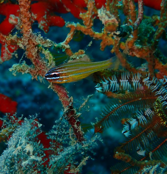
These comfortable environmental conditions also enable various fish species to live, spawn, and reproduce optimally in the Coral Triangle’s waters. This unique and fascinating marine environment has led Indonesia and China to agree on conducting a marine expedition using Sun Yat-sen University’s latest research vessel, Zhongsan Dakeu, in the coming years.
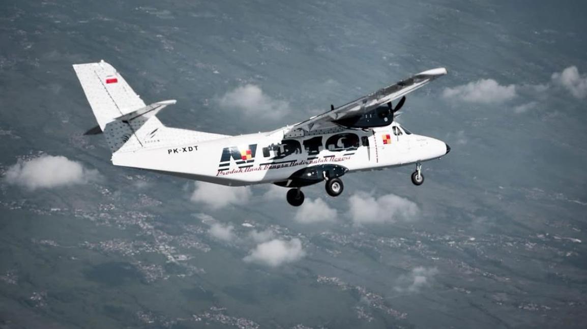
N219 Nurtanio is a new generation multi-purpose aircraft, which is designed to carry 19 passengers with the largest cabin cross section of its class. (Doc PT Dirgantara Indonesia)
The National Development Planning Agency (Bappenas) has launched a roadmap for the development of the national aerospace industry with the vision: “A Resilient and Competitive Aerospace Industry Towards Golden Indonesia 2045.” One of the four pillars of the aerospace industry ecosystem is the development of the aircraft manufacturing industry, with three main targets: producing turboprop aircraft with a capacity of fewer than 100 passengers, manufacturing unmanned aerial vehicles (UAVs) for cargo transportation, and becoming a leading producer of flight simulators.
According to the Bappenas roadmap, the mission in developing the aircraft manufacturing industry is: “Strengthening the aircraft industry, components, and aerospace supply chain.” The next step is to implement the National Aerospace Industry Development Roadmap, which was launched in 2023.
doc PT Dirgantara Indonesia
The Center for Technology & Innovation Studies (CTIS) recently organized a discussion on the development of Indonesia’s aerospace industry, featuring Ir. Agung Nugroho, a former aircraft designer at PT Dirgantara Indonesia and currently the founder and CEO of PT Aviasi Indonesia Maju. The discussion was moderated by Professor Anton Adibroto, Chairman-I of CTIS and a Professor of Aerospace Engineering at the University of Malaysia – Kelantan (UMK).
Agung Nugroho began his presentation by outlining the history of Indonesia’s aviation industry since the country’s independence. He highlighted how, at that time, technicians from the People’s Security Army – Air Force (TKR – Udara) successfully repaired and flew former Japanese Air Force aircraft. Notably, on July 29, 1947, Indonesia successfully conducted an aerial bombing operation targeting Semarang, Ambarawa, and Salatiga.
By 1950, aircraft repair and testing operations were moved to Andir Air Base in Bandung. Subsequently, the Bandung Institute of Technology (ITB) established its Aeronautical Engineering Department in 1960. In the 1970s, the Nurtanio Aviation Industry Institute (LIPNUR) was founded at Andir Air Base, later renamed Husein Sastranegara Air Base. This marked the beginning of modern aircraft manufacturing in Indonesia with the establishment of PT Industri Pesawat Terbang Nurtanio (IPTN), which produced aircraft such as NC-212, CN-235, N-250, C-295, and assembled helicopters like NBO-105, AS-332 Super Puma, Bell-412, and Cougar, in collaboration with France.
doc PT Dirgantara Indonesia
Agung Nugroho explained that despite domestic political challenges, PT IPTN, later renamed PT Dirgantara Indonesia (PT DI), continued to innovate by developing the N-219 “Nurtanio” aircraft and manufacturing components for the F-16 fighter jet ordered by General Dynamics (USA) and Airbus (France).
As the world’s largest archipelagic country, Indonesia must have a strong aircraft and shipbuilding industry to support inter-island transportation. Data from the International Air Transport Association (IATA) projects that by 2036, Indonesia will rank 4th globally in aircraft demand, following China, the United States, and India.
Agung emphasized that Indonesia’s aerospace industry development from 1970 to 2000 provides a solid foundation for future growth. The country already possesses expertise in design, development, system integration, and aircraft certification. The key challenge now is to continue national strategic aircraft programs, optimize existing industrial infrastructure, and enhance capabilities continuously—starting with fulfilling domestic demand before entering the international market.
Additionally, research, innovation, and human resource development must be accelerated to support aerospace industry growth. Agung also highlighted the importance of government commitment and national leadership in fostering a sustainable aerospace industry ecosystem. He concluded by mentioning that the soon-to-be-established financial institution Danantara will provide a much-needed boost for long-term strategic industries in Indonesia, particularly in aircraft manufacturing.
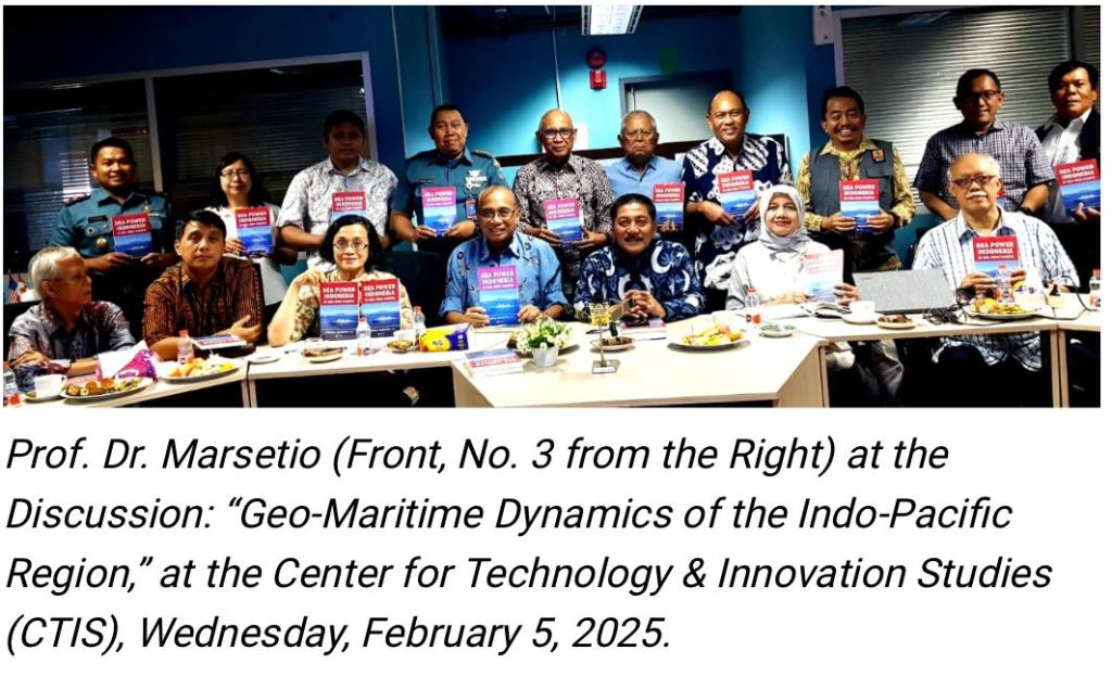
The Latin phrase “Si vis pacem, para bellum” means “If you want peace, prepare for war.” Its implementation for a maritime nation includes having strength for naval defense, maritime security, and safety, as well as carrying out various societal activities at sea. As the world’s largest archipelagic country, Indonesia must internalize and uphold this principle. This was the conclusion of the Center for Technology & Innovation Studies (CTIS) discussion on Wednesday, February 5, 2025. Speaking at the discussion, which took the theme “Geo-Maritime Dynamics of the Indo-Pacific Region: Indonesia in Managing Potential Conflict Areas into Zones of Cooperation,” was Admiral (Ret.) Prof. Dr. Marsetio, a professor at the Indonesian Defense University and Chief of Staff of the Indonesian Navy from 2012 to 2014. The session was moderated by Dr. Nadirah, Deputy Secretary-General of CTIS and an environmental expert from BRIN.
Prof. Marsetio began his presentation by discussing Indonesia as the world’s largest archipelagic state, recognized under the United Nations Convention on the Law of the Sea 1982 (UNCLOS ’82), which has been ratified by 168 countries. In UNCLOS ‘82, it is stated that Indonesia’s territorial sea extends 12 miles from the outermost points of its outermost islands, known as baseline points. These baseline points are connected to form a baseline, determining Indonesia’s territorial sea sovereignty, covering 3.1 million square kilometers. Within this maritime area, Indonesia has the right to raise its national flag, the Red and White.
Additionally, Indonesia’s Exclusive Economic Zone (EEZ) extends 200 miles from the coastline, covering an area of 2.7 million square kilometers. Within the EEZ, Indonesia does not have full sovereignty over the waters, but all economic resources above the water, within the water, on the seabed, and beneath the seabed belong to Indonesia. Furthermore, if Indonesia can scientifically prove that its sedimentary rock layer extends up to 350 miles from the coast, the area, known as the continental shelf, along with its potential resources—mainly minerals and oil & gas—also belongs to Indonesia.
Naturally, Indonesia’s vast maritime territory of 5.8 million square kilometers must be safeguarded, secured, and its resources optimally utilized for the prosperity of the Indonesian people. This is particularly critical in the North Natuna Sea, which is rich in fish and has significant oil and gas potential but is frequently entered by foreign fishing vessels from Vietnam and China. Ironically, both of these countries have also ratified UNCLOS ’82.
Marsetio emphasized that one of the world’s major maritime conflict zones could arise in the South China Sea. Historically, the United States Navy has had dominant influence in the Pacific Ocean and the South China Sea, but this presence is now being challenged by China’s growing naval power. Furthermore, warships from NATO member countries such as Italy and France have begun patrolling the South China Sea, with their movements being closely monitored by the Chinese Navy and the China Coast Guard. Even a minor friction or provocation could ignite conflict in these waters.
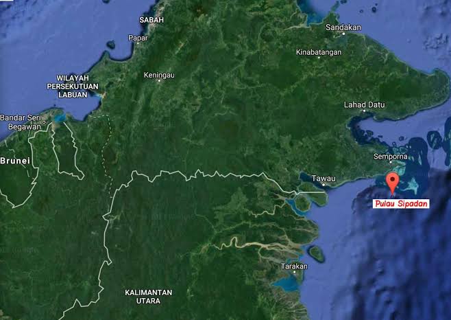
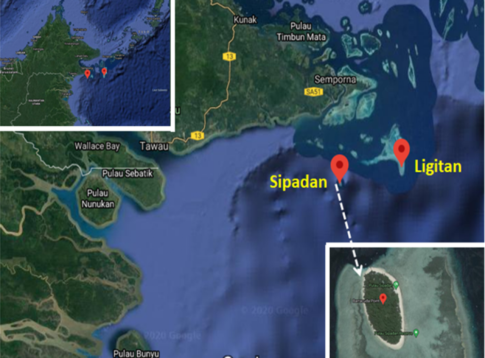
Sipadan and Ligitan islands. (dok app.goo.gl)
Adding to the tensions, Chinese fishing vessels have frequently intruded into Indonesia’s EEZ. Marsetio stressed that Indonesia must maintain a strong presence in the North Natuna Sea—both in terms of defense and security forces, conducting marine research, and ensuring that Indonesian fishers operate there in significant numbers. If the number of Indonesian fishing vessels and fishers is lower than that of foreign fishers, history could repeat itself—similar to the loss of Sipadan and Ligitan Islands in 2002.
When the territorial dispute over Sipadan and Ligitan Islands was brought to the International Court of Justice (ICJ) in The Hague, Netherlands, the judges posed a critical question: “Who has been maintaining, developing, managing, and actively engaging in activities on Sipadan and Ligitan?” The answer was “Malaysia.” As a result, the ICJ ruled in favor of Malaysia. This loss occurred because Indonesia had never actively engaged in or managed these islands.
Professor Marsetio, who frequently represents Indonesia at International Maritime Organization (IMO) meetings, proposed a cooperative approach to utilizing Indonesia’s EEZ—both with domestic and international partners.
As an initial step, Marsetio, who currently serves as an advisor to the Minister of Higher Education, Science, and Technology, announced that a research expedition in the North Natuna Sea will soon be conducted. This will involve the Indonesian Navy’s Hydro-Oceanographic Survey Vessel and invite Indonesian marine scientists, with research funding provided by the Indonesia Endowment Fund for Education (LPDP). Beyond gathering marine data and research findings, the presence of the Indonesian Navy’s survey vessel will further assert Indonesia’s sovereignty over the North Natuna Sea.
For international collaboration, Professor Marsetio cited specific provisions in UNCLOS ’82 as the legal framework, particularly Article 62, which states that marine resources—especially fisheries—within an EEZ belong to the coastal state. If the coastal state is unable to fully exploit these resources, it can cooperate with other countries for joint resource utilization. For Indonesia, as a coastal state, entering into fair and transparent agreements with foreign partners to utilize its marine resources—such as tuna fisheries—could be a viable strategy.
Through these various initiatives and under the legal umbrella of UNCLOS ’82, numerous cooperative approaches can be adopted instead of resorting to conflict.
“The most important thing is ensuring that we are always present in our own waters,” Admiral (Ret.) Prof. Dr. Marsetio concluded.