Diskusi yang digelar Centre for Technology and Innovation Studies pada Rabu, 20 Agustus 2025, menghadirkan narasumber Dr. Anastasia Kuswardani, Kepala Pusat Standardisasi dan Sertifikasi Kementerian Kelautan dan Perikanan. (Dok CTIS)
Melelehnya salju di benua Antartika berpengaruh besar terhadap kondisi iklim global, termasuk Indonesia. Hal ini menjadi pembahasan dalam diskusi yang digelar Centre for Technology and Innovation Studies pada Rabu, 20 Agustus 2025, menghadirkan narasumber Dr. Anastasia Kuswardani, Kepala Pusat Standardisasi dan Sertifikasi Kementerian Kelautan dan Perikanan.
Adapun tema yang diangkatBenua Antartika dan Perubahan Iklim di Kepulauan Nusantara.
Anastasia merupakan salah satu ekspedisioner Australia’s Antarctic Programme, Australian Antarctic Division 2004–2005. Saat itu, Indonesia mengirim dua peneliti perempuan, salah satunya Anastasia yang berkolaborasi dengan akademisi dari Universitas Sam Ratulangi.
Diskusi yang digelar Centre for Technology and Innovation Studies pada Rabu, 20 Agustus 2025, menghadirkan narasumber Dr. Anastasia Kuswardani (no 3 duduk dari kanan), Kepala Pusat Standardisasi dan Sertifikasi Kementerian Kelautan dan Perikanan. (Dok CTIS)
Lulusan Geofisika dan Meteorologi ITB serta doktor bidang Physical Oceanography dari Ocean University of China ini berbagi pengalaman setahun penuh melakukan riset di Antartika. Ekspedisi yang berlangsung sejak Desember 2004 hingga Februari 2005 itu menggunakan kapal riset Aurora Australis milik Australia.
Rute perjalanan dari Fremantle ke Davis Station Hobart, 23 Desember 2004 hingga 17 Februari 2005
Cadangan Air Tawar Dunia
Menurut Anastasia, Antartika menyimpan 60–70% cadangan air tawar Bumi dalam bentuk es. Data British Antarctic Survey menyebutkan 70% air tawar global tersimpan di kawasan ini, sementara USGS mencatat 91% gletser dunia berada di Antartika. Perubahan yang terjadi di sana sangat relevan dengan kenaikan muka laut di seluruh dunia, termasuk Nusantara.
Hasil Penelitian Ekspedisi
Tim ekspedisi melakukan berbagai riset, mulai dari pengukuran arus laut dalam, suhu, salinitas, hingga massa gunung es. Hasilnya menunjukkan adanya peningkatan suhu permukaan laut yang memengaruhi densitas air. Data 2005 memperlihatkan air laut di Samudra Selatan lebih tawar dan ringan dibandingkan pengamatan pada 1995.
“Laju perubahan iklim memiliki pola yang sama, namun dengan magnitudo lebih besar dibandingkan periode akhir 1960-an hingga 1990-an,” jelas Anastasia.
Ia menambahkan, mencairnya es Antartika dapat memengaruhi sirkulasi termohalin global, memperlambat Antarctic Circumpolar Current (ACC), dan berdampak pada perubahan iklim hingga ke Samudra Hindia.
Dampak bagi Indonesia
Bagi Indonesia, perubahan di Antartika tercermin pada pola monsun Asia–Australia, curah hujan, hingga musim ikan. Cuaca ekstrem, gelombang tinggi, rob, serta paceklik ikan semakin sering dirasakan nelayan.
Fenomena migrasi ikan dan paus terdampar di perairan Indonesia juga dikaitkan dengan perubahan suhu laut. “Ikan-ikan akan mencari habitat yang lebih nyaman, sehingga terjadi migrasi besar-besaran,” kata Anastasia.
Pada 2005, pemerintah memasang plakat bertanda tangan Presiden Megawati Soekarnoputri di Davis Station sebagai bentuk apresiasi terhadap para peneliti Indonesia yang ikut serta dalam riset global tersebut. (Dok CTIS)
Seruan Menjaga Laut
Untuk mengurangi dampak perubahan iklim, Anastasia menekankan pentingnya menjaga kesehatan laut, antara lain dengan mengurangi plastik sekali pakai, tidak membuang sampah ke laut, serta menghemat energi.
Ekspedisi Antartika sendiri memiliki arti penting bagi Indonesia. Pada 2005, pemerintah memasang plakat bertanda tangan Presiden Megawati Soekarnoputri di Davis Station sebagai bentuk apresiasi terhadap para peneliti Indonesia yang ikut serta dalam riset global tersebut. ***
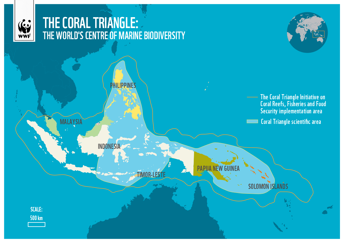
The Coral Triangle Area consistently draws the attention of marine scientists worldwide. Why does this 75,000-square-kilometer coral reef region, encompassing the waters of six countries—Indonesia, Malaysia, the Philippines, Papua New Guinea, Timor Leste, and the Solomon Islands—host such extraordinary marine biodiversity? This region is home to 520 coral species, around 3,000 species of fish, and 150 million coastal residents who depend on marine resources, with an economic potential estimated at USD 2.5 billion annually. No other marine region in the world matches its biodiversity richness.
While the Amazon rainforest in Brazil boasts the world’s highest terrestrial biodiversity—with 16,000 plant species, 1,300 bird species, and 430 mammal species—the Coral Triangle Area, often called the “Amazon of the Sea,” holds the title for marine biodiversity.
The Coral Triangle Area
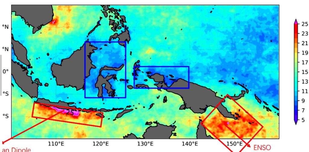
Global scientists continue to investigate the reasons behind the Coral Triangle’s incredible richness. Indonesian and Chinese marine experts have linked the presence of coral reefs in Indonesian waters to the phenomenon of marine heat waves (MHW) frequently occurring in the archipelago’s waters. At the International Conference for Sustainable Coral Reefs held in Manado from December 13–15, 2024, Indonesian researcher Dr. Salvienty Makarim, along with Professors Linhai Wang and Weidong Yu1 from Sun Yat-sen University in China, presented their analysis of MHW in Indonesian waters, particularly in the waters of Sulawesi and Northern Papua.
Data from the U.S. National Oceanic and Atmospheric Administration (NOAA) indeed shows the presence of marine heat waves in Indonesia’s waters. However, these MHWs do not significantly impact coral reef bleaching. Sea surface temperatures in the Coral Triangle region remain stable at just 5–7 degrees Celsius, unlike the MHW in Thailand, where sea surface temperatures can reach 31 degrees Celsius, causing severe coral bleaching and mortality.
source: https://kkprajaampat.com/en/the-reefs/
The Indonesian-Chinese researchers did not stop at this finding. During the El Niño climate variability, which raised sea surface temperatures in Southern Papua and the Torres Strait to 23 degrees Celsius, sea surface temperatures in Sulawesi and Northern Papua waters remained steady at 5–7 degrees Celsius. This stability allows coral reefs to thrive and reproduce, supported by ocean currents flowing from the Pacific Ocean to the Indian Ocean, which maintain favorable conditions for diverse coral species to live healthily and sustainably.
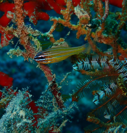
These comfortable environmental conditions also enable various fish species to live, spawn, and reproduce optimally in the Coral Triangle’s waters. This unique and fascinating marine environment has led Indonesia and China to agree on conducting a marine expedition using Sun Yat-sen University’s latest research vessel, Zhongsan Dakeu, in the coming years.
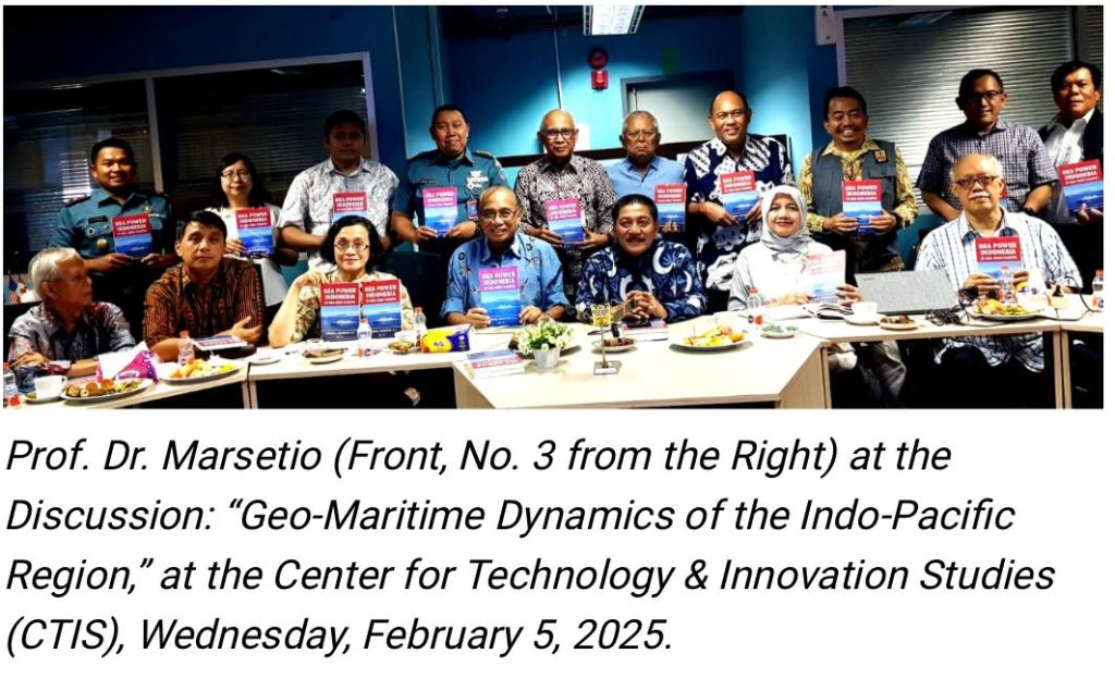
The Latin phrase “Si vis pacem, para bellum” means “If you want peace, prepare for war.” Its implementation for a maritime nation includes having strength for naval defense, maritime security, and safety, as well as carrying out various societal activities at sea. As the world’s largest archipelagic country, Indonesia must internalize and uphold this principle. This was the conclusion of the Center for Technology & Innovation Studies (CTIS) discussion on Wednesday, February 5, 2025. Speaking at the discussion, which took the theme “Geo-Maritime Dynamics of the Indo-Pacific Region: Indonesia in Managing Potential Conflict Areas into Zones of Cooperation,” was Admiral (Ret.) Prof. Dr. Marsetio, a professor at the Indonesian Defense University and Chief of Staff of the Indonesian Navy from 2012 to 2014. The session was moderated by Dr. Nadirah, Deputy Secretary-General of CTIS and an environmental expert from BRIN.
Prof. Marsetio began his presentation by discussing Indonesia as the world’s largest archipelagic state, recognized under the United Nations Convention on the Law of the Sea 1982 (UNCLOS ’82), which has been ratified by 168 countries. In UNCLOS ‘82, it is stated that Indonesia’s territorial sea extends 12 miles from the outermost points of its outermost islands, known as baseline points. These baseline points are connected to form a baseline, determining Indonesia’s territorial sea sovereignty, covering 3.1 million square kilometers. Within this maritime area, Indonesia has the right to raise its national flag, the Red and White.
Additionally, Indonesia’s Exclusive Economic Zone (EEZ) extends 200 miles from the coastline, covering an area of 2.7 million square kilometers. Within the EEZ, Indonesia does not have full sovereignty over the waters, but all economic resources above the water, within the water, on the seabed, and beneath the seabed belong to Indonesia. Furthermore, if Indonesia can scientifically prove that its sedimentary rock layer extends up to 350 miles from the coast, the area, known as the continental shelf, along with its potential resources—mainly minerals and oil & gas—also belongs to Indonesia.
Naturally, Indonesia’s vast maritime territory of 5.8 million square kilometers must be safeguarded, secured, and its resources optimally utilized for the prosperity of the Indonesian people. This is particularly critical in the North Natuna Sea, which is rich in fish and has significant oil and gas potential but is frequently entered by foreign fishing vessels from Vietnam and China. Ironically, both of these countries have also ratified UNCLOS ’82.
Marsetio emphasized that one of the world’s major maritime conflict zones could arise in the South China Sea. Historically, the United States Navy has had dominant influence in the Pacific Ocean and the South China Sea, but this presence is now being challenged by China’s growing naval power. Furthermore, warships from NATO member countries such as Italy and France have begun patrolling the South China Sea, with their movements being closely monitored by the Chinese Navy and the China Coast Guard. Even a minor friction or provocation could ignite conflict in these waters.
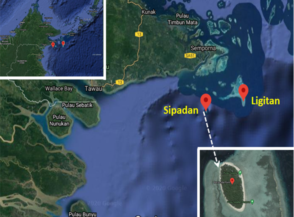
Sipadan and Ligitan islands. (dok app.goo.gl)
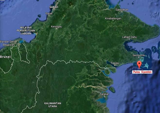
Adding to the tensions, Chinese fishing vessels have frequently intruded into Indonesia’s EEZ. Marsetio stressed that Indonesia must maintain a strong presence in the North Natuna Sea—both in terms of defense and security forces, conducting marine research, and ensuring that Indonesian fishers operate there in significant numbers. If the number of Indonesian fishing vessels and fishers is lower than that of foreign fishers, history could repeat itself—similar to the loss of Sipadan and Ligitan Islands in 2002.
When the territorial dispute over Sipadan and Ligitan Islands was brought to the International Court of Justice (ICJ) in The Hague, Netherlands, the judges posed a critical question: “Who has been maintaining, developing, managing, and actively engaging in activities on Sipadan and Ligitan?” The answer was “Malaysia.” As a result, the ICJ ruled in favor of Malaysia. This loss occurred because Indonesia had never actively engaged in or managed these islands.
Professor Marsetio, who frequently represents Indonesia at International Maritime Organization (IMO) meetings, proposed a cooperative approach to utilizing Indonesia’s EEZ—both with domestic and international partners.
As an initial step, Marsetio, who currently serves as an advisor to the Minister of Higher Education, Science, and Technology, announced that a research expedition in the North Natuna Sea will soon be conducted. This will involve the Indonesian Navy’s Hydro-Oceanographic Survey Vessel and invite Indonesian marine scientists, with research funding provided by the Indonesia Endowment Fund for Education (LPDP). Beyond gathering marine data and research findings, the presence of the Indonesian Navy’s survey vessel will further assert Indonesia’s sovereignty over the North Natuna Sea.
For international collaboration, Professor Marsetio cited specific provisions in UNCLOS ’82 as the legal framework, particularly Article 62, which states that marine resources—especially fisheries—within an EEZ belong to the coastal state. If the coastal state is unable to fully exploit these resources, it can cooperate with other countries for joint resource utilization. For Indonesia, as a coastal state, entering into fair and transparent agreements with foreign partners to utilize its marine resources—such as tuna fisheries—could be a viable strategy.
Through these various initiatives and under the legal umbrella of UNCLOS ’82, numerous cooperative approaches can be adopted instead of resorting to conflict.
“The most important thing is ensuring that we are always present in our own waters,” Admiral (Ret.) Prof. Dr. Marsetio concluded.
Pembangunan Pulau Batam-Rempang-Galang (Barelang), Provinsi Kepulauan Riau, sejak 1973 bisa menjadi lesson learned untuk pembelajaran pembangunan Ibukota Nusantara (IKN) Nusantara di Kalimantan Timur.
Pembangunan IKN Nusantara harus yang mencakup fokus pada skala prioritas peruntukan wilayah, ketersediaan sumberdaya manusia (SDM) handal, regulasi yang kondusif untuk menarik investasi dan pembangunan non-fisik, tidak hanya pembangunan sarana prasarana fisik.
Demikian antara lain butir butir kesimpulan Diskusi yang digelar Center for Technology & Innovation Studies (CTIS), di Jakarta, Rabu 11 Oktober 2023. Diskusi yang dipandu Ketua Komite Pengembangan Wilayah CTIS, Dr. Tusy Adibroto menampilkan pembicara diantaranya Prof. Antony Sihombing dari Fakultas Teknik Universitas Indonesia, Dr. Tjahjo Prionggo, mantan Direktur Perencanaan Badan Otorita Pembangunan Barelang (Opdib Barelang) dan Dr.Wicaksono Sarosa dari institusi Jasa Konsultansi Ruang Waktu.
Dr. Tjahjo Prionggo menyampaikan bahwa saat Batam mulai dibangun pada 1973 lalu, seluruh Pulau Batam, Rempang dan Galang masih berupa kawasan hutan tak berpenghuni.
Sedikit ada permukiman Desa Nelayan di pinggiran pantai.
Melalui Keppres No.41/Th.1973, Batam mulai dibangun sebagi kawasan industri, pusat perdagangan, pusat logistik dan juga merupakan destinasi wisata. Ini memanfaatkan lokasi strategis Batam di jalur pelayaran internasional dan, sesuai “Teori Balon” BJ Habibie sebagai Ketua Otorita Batam, maka kelebihan investasi di Singapura akan mengalir ke Batam karena luas wilayah dan sumberdaya Singapurayang terbatas.
Pembangunan Kota Batam, Provinsi Kepulauan Riau yang menjadikan kota itu terus berkembang. (dok SSC Batam)
Kala itu, belum ada wilayah perdagangan bebas lain di sekitar Singapura, belum ada Johor Baru, belum ada Penang yang maju, juga belum ada Pelabuhan Internasional Malaka, belum ada Port Klang dan Kawasan Tanjung Pelepas di Malaysia, yang maju. Kala itu, peluang untuk memposisikan Batam sebagai pusat perdagangan internasional sangat besar.
Pembangunan sarana dan prasarana di Batam, Rempang dan Galang dipacu. Jembatan Penghubung tiga pulau Barelang selesai dibangun pada tahun 1997. Pembangunan fisik yang pesat di Batam mengesampingkan aspek regulasinya.
Alhasil, penduduk ilegal berdatangan ke Barelang untuk mengadu nasib. Pasca reformasi 1998, dengan maraknya otonomi daerah yang menjurus ke desentralisasi kewenangan dari Pusat ke Daerah, maka terbentuk Pemerintahan Kota Batam.
Sesuai UU No.26/Th.2007 Tentang Penataan Ruang, status Batam masuk kedalam Kawasan Strategis Nasional. Kerancuan regulasi tentang Otonomi Daerah dengan Tata Ruang pun muncul.
Ditambah lagi, regulasi tentang posisi Walikota Batam yang juga harus memimpin Badan Pengelola Kawasan Barelang yang bersifat Nasional. Belum lagi tumpang tindih dengan regulasi yang berkaitan dengan Zona Perdagangan Bebas Barelang. Kesemuanya ini mengakibatkan investasi di Barelang tersendat.
Dilain pihak, wilayah-wilayah perdagangan bebas di kawasan, seperti Johor Baru, berkembang pesat. Oleh sebab itu, regulasi dan birokrasi nampaknya perlu dirampingkan agar wilayah Barelang tetap kompetitif sebagai wilayah pertumbuhan ekonomi regional yang potensial.
Belajar dari pengalaman pembangunan Barelang ini maka dalam pembangunan Ibukota Nusantara (IKN), di Kabupaten Penajam Paser Utara, Kalimantan Timur maka urusan regulasi nampaknya perlu dirapikan terlebih dahulu.
Pelabuhan di Batam menjadi salah satu infrastruktur ekonomi Provinsi Kepulauan Riau. (dok SSC Batam)
Dr. Wicaksono Sarosa memaparkan UU No.3/Th.2022 Tentang Ibukota Negara yang telah dilengkapi beragam Peraturan Pemerintah (PP), Peraturan Presiden (Perpres) serta Peraturan Kepala Otorita IKN. Keberadan IKN juga strategis, berada di tengah Indonesia, merupakan pusat pertumbuhan ekonomi baru dan kota masa depan yang ramah lingkungan serta smart & green city berteknologi digital.
Aspek teknologi baru, memanfaatkan Industri 4.0, harus dimunculkan pada pembangunan IKN. Hal ini digarisbawahi oleh Professor Anthony Sihombing. Apalagi pada kurun 2020 – 2021 muncul pandemi Covid 19 yang menyodorkan teknologi Kecerdasan Artifisial (Artifical Intelligence – AI) semakin masif pada perkembangan metropolitan modern. Ini akan mengurangi kebutuhan ruang perkantoran, akan mengurangi keberadaan toko dan mall, didukung penggunaan sistem transportasi yang ramah lingkungan, serta jaringan telekomunikasi yang harus berteknologi mutakhir.
Ini semua perlu diantisipasi pada proses pembangunan IKN yang sedang berprogress saat ini agar muncul suatu kota metropolitan baru ditengah Negara Kepulauan Nusantara, yang akan mencerminkan Indonesia sebagai negara masa depan yang maju dan modern.
Disinilah peran SDM menjadi penting, seperti disampaikan Tjahjo Prionggo, yang juga diamini kedua pembicara lainnya, karena apabila kesiapan SDM, utamanya SDM lokal, tidak ditingkatkan maka para penduduk lokal akan hanya menjadi penonton, tidak bisa berpartisipasi lebih aktif, akibat rendahnya tingkat produktivitas masyarakatnya.
Seperti dicontohkan beberapa wilayah pertumbuhan ekonomi di Indonesia yang memiliki tingkat GDP Per-Kapita tinggi, namun ternyata ketimpangan ekonominya juga tinggi karena sebagian besar sumberdaya dimiliki oleh sebagian kecil kelompok masyarakat. Oleh sebab itu, anggota CTIS yang juga Sekjen Akademi Ilmu Pengetahuan Indonesia (AIPI) Chairil Abdini mengingatkan tentang pentingnya pembangunan non-fisik, seperti budaya lokal dan aspek sosial penduduk, disertakan di samping pembangunan fisik infrastruktur semata, agar wilayah baru yang muncul lebih manusiawi dengan kehidupan penduduk yang lebih sejahtera dan harmonis.
Dalam rencana pembangunan IKN, jumlah penduduk IKN dipatok pada 1,9 juta orang pada tahun 2050.
Salah satu jenis pembangunan di IKN yang direkomendasikan oleh Dr. Unggul Priyanto, Ketua Komite Energi CTIS, yang juga mantan Kepala Badan Pengkajian dan Penerapan Teknologi (BPPT), adalah pembangunan Pusat Iptek Kelautan Indonesia di Kabupaten Penajam Paser Utara ini.
Sejak 2012, BPPT dan Pemerintah Perancis telah menyusun rencana Pusat Iptek Kelautan ini, yang juga akan menjadi Pelabuhan sandar kapal kapal riset Indonesia, karena lokasinya di tengah tengah negara kepulauan Nusantara.
Program kerjasama RI – Perancis ini sudah masuk kedalam Blue Book Bappenas 2015, dan pada April 2015 lalu juga sudah ditinjau oleh Menko Kemaritiman kala itu, Indroyono Soesilo, untuk segera diimplementasikan. Dengan ditetapkannya Kabupaten Penajam Paser Utara sebagai IKN, nampaknya program Pusat Iptek Kelautan Indonesia ini dapat dibahas dan dihidupkan kembali. ***
sumber : https://forestinsights.id/barelang-bisa-jadi-pembelajaran-untuk-ikn-nusantara-ctis-pembangunan-non-fisik-penting/